Calgary Building Permit Map: Explore Construction and Development Activity Across the City
Calgary is constantly evolving. New homes are being built, older properties are being renovated, and commercial developments continue to reshape the city’s skyline. Also, there has been a surge in secondary suite construction and basement development. But how can residents, contractors, and investors easily see where construction activity is happening?
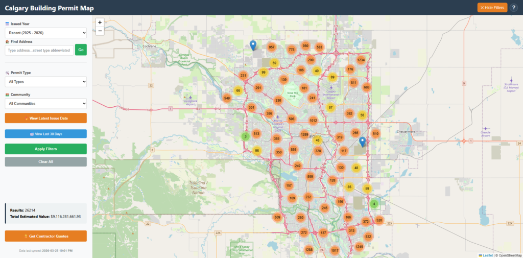
To make this information easier to explore, we created the Calgary Building Permit Map, an interactive tool that visualizes building permit activity across Calgary.
You can explore the live interactive map here:
The tool allows users to quickly identify development activity, renovation projects, demolition permits, and estimated construction investment happening throughout the city.
What Is a Building Permit and Why It Matters
A building permit is an official approval issued by the City that allows construction, renovation, demolition, or environmental restoration work to begin.
Building permit data provides valuable insight into:
• Where new homes are being built
• Neighbourhoods experiencing renovation activity
• Large commercial or multi-family developments
• Demolition projects indicating redevelopment
• Total construction investment in different communities
Because permits are issued before construction begins, they often provide one of the earliest signals of development trends in a city.
Introducing the Calgary Building Permit Map
The Calgary Building Permit Map transforms raw permit data into an interactive map that allows users to visually explore construction activity across the city.
Instead of browsing spreadsheets or large datasets, users can explore development patterns by simply navigating the map.
Each marker on the map represents a building permit issued for a specific location.
Users can zoom in to see activity at the neighbourhood level or zoom out to observe development trends across the entire city.
Explore the Calgary Building Permit Map here.
Explore the tool here:
Key Features of the Building Permit Map
Interactive Map of Permit Locations
The app displays building permits geographically across Calgary, allowing users to quickly see where development activity is taking place.
The interactive design makes it easy to explore:
• Individual permit locations
• Clusters of construction activity
• Development patterns across communities
Filter by Work Class
The application allows users to filter permits by work class group, including:
New
New construction projects, such as new homes or new commercial developments.
Improvement
Renovations or upgrades to existing structures.
Demolition
Removal of existing buildings before redevelopment.
Unspecified
Permits that do not fall into a clearly defined category.
Filtering by work class allows users to quickly identify whether construction activity in a neighborhood is primarily new development or renovation.
Filter by Permit Type
Users will also be able to filter permits based on the type of construction project the future enhancements.
Permit types include:
• Single Construction Permit
• Commercial / Multi-Family Project
• Residential Improvement Project
• Demolition
• Environmental Restoration Permit
These categories help users focus on the types of projects that interest them most.
For example:
A homeowner might explore residential improvement permits, while a developer may focus on commercial or multi-family projects.
Estimated Construction Value
Each permit also includes an estimated construction value, which provides an indication of the scale of the project.
This allows users to identify:
• High-value commercial developments
• Major residential construction projects
• Significant renovation investments
Tracking construction values can reveal how much investment is flowing into different parts of the city.
Who Can Use the Calgary Building Permit Map?
The tool can be useful for a wide range of people.
Homeowners
Homeowners can explore renovation activity in their neighbourhood. For example, you may notice an increase in basement developments, garage construction, or home expansions nearby.
Contractors and Construction Professionals
Contractors can identify neighbourhoods where renovation or construction activity is increasing, helping them discover potential project opportunities.
Real Estate Investors
Real estate investors can use permit data to identify areas experiencing redevelopment or increased construction activity.
Urban Development Enthusiasts
Anyone interested in Calgary’s growth can explore how development patterns are changing across the city.
Watch the Map App in Action
We created a short video demonstration showing how to use the Calgary Building Permit Map.
The video highlights:
• How to explore construction activity across Calgary
• How to filter permits by work class and project type
• How to identify high-value construction projects
Upcoming Features and Enhancements
The Calgary Building Permit Map will continue to evolve with new features designed to provide even more insights.
Upcoming enhancements include:
Detailed Permit Descriptions
Future versions of the app will include a short description of the work permitted.
This will make it easier to understand exactly what type of construction is taking place.
Examples include:
• New home construction
• Basement development
• Secondary suite development
• Garage construction
• Major residential renovations
These descriptions will provide additional context beyond permit type and estimated construction value.
Highlighting Housing Development Trends
Future updates will also highlight key housing projects such as:
• New home builds
• Secondary suites
• Basement developments
• Major residential additions
These insights can help users better understand how Calgary’s housing supply is evolving.
Contractor Directory Coming Soon
Another feature currently in development is a local contractor directory that will connect homeowners with construction professionals.
The directory will include contractors specializing in:
• Home renovations
• Basement development
• Secondary suites
• Residential construction
• Demolition services
• General contracting
The goal is to make it easier for homeowners to find qualified professionals for projects similar to those shown in the building permit data.
Contractors interested in being featured will soon be able to submit their business information for inclusion in the directory.
Explore Calgary Development Activity Today
The Calgary Building Permit Map is designed to make development data easier to understand and explore.
By transforming public permit data into an interactive visualization, the tool provides valuable insights into how Calgary is growing and evolving.
Explore the map here:
Calgary Current Property Assessment Map
Stay tuned for the enhancement of the Calgary Current Property Assessment Map with better functionality and faster loading time.
The City has released this year’s current property assessment. Watch for the forecast of future total property assessment values of the city and growing communities.
About Cuttell Analytics
Cuttell Analytics focuses on turning public data into actionable insights through data analytics, visualization, and interactive tools.
The Calgary Building Permit Map is part of an ongoing effort to make local data more accessible to residents, professionals, and businesses.
More data-driven tools and insights are coming soon.